Speculating at the Nation-State Scale
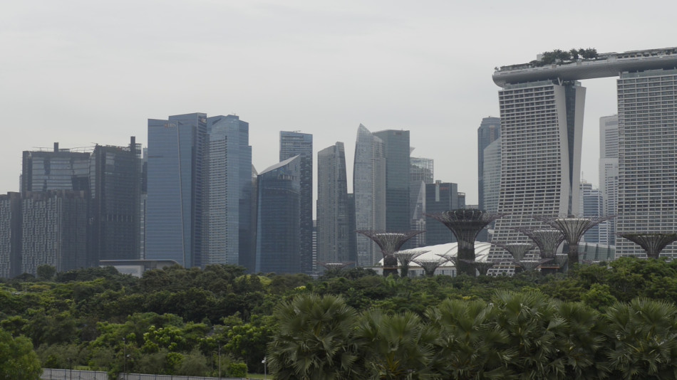
The project that is Singapore began slightly less than two hundred years ago. Before its colonisation by the British in 1822 initiated by Sir Stamford Raffles, there was little official documentation about the small island on the southern tip of Malaysia. Different names and rough geographical markers existed—charted by Chinese merchants who sailed the Straits of Malacca. Today, Singapore is Southeast Asia’s business and financial hub, internationally praised as a role model for urban development, a "First World oasis in a Third World region". Its rapid transition is based on a rigid and meticulous urban planning process whose central tenets are the extension and intensification of land. The resulting manipulation of the social and material fabric can be traced along the transformation of one particular material: sand.
Singapore’s nation-building is directly correlated to land reclamation and the trading of sand. Being the biggest sand importer in the world, it has extended its landmass by about a quarter since 1960. Further projections amount for a total extension of thirty percent by 2030. Veiled under the guise of necessity, it might rather be described as “technology of the Singaporean self”. Being too small of an island to compete within the Asian and by extension the world economy, Singapore’s self-conception is deeply ingrained in an inferiority complex. It is disputable that Singapore does not have space left for development, yet the right to more space for economic growth is a common thread throughout all official communication. Singapore’s alleged smallness is a strategic and communicative vehicle to legitimise its reclamation efforts against all odds and as the only viable choice to ensure geopolitical and economic superiority. By maintaining a constant state of crisis and vulnerability, Singapore’s one-party government normalises a history of appropriation and exploitation in order to ensure linear economic and spatial growth.
In the following, I would like to point out the objects and practices fundamental to Singapore’s nation-building process and the way they mirror the changing relationship to sand. I will begin by focussing on the so-called Master Plan and Concept Plan, two zoning plans which translate Singapore’s vision of a global city into the material and immaterial fabric of the city-state. Fundamental to the urban planning scheme is a paradigm of total flexibility with land being as blank as a drawing board and sand as liquid as money. In these planning documents sand is rendered an abstract unit of exchange, with no symbolic value, operational only as fill material.
From the mid 1980s onwards, the establishment of a legal framework should have ensured the ongoing liquidity of ground and thus of capital. In the initial stage, the Foreshores Act was released as a measure to clear the seabed and maritime space from any claims of access, ownership or compensation from locals. Furthermore, the Sand Procurement Scheme issued by the Building and Construction Authority, particularly its continuous amendments, further omit the dubious means by which sand is procured.
Together, these documents point towards the difficult relationship between material flows and their politics. Sand, after being extracted and thus taken out of context, becomes re-politicised when deployed as land and territory. This process gets further accelerated by the imposition of export bans which lead to an increase in price and fuel illegal mining practices. With Singapore’s nation-building depending on a continuous flow of sand, the “cheap resource” quickly turns into a precious good and a risky asset.
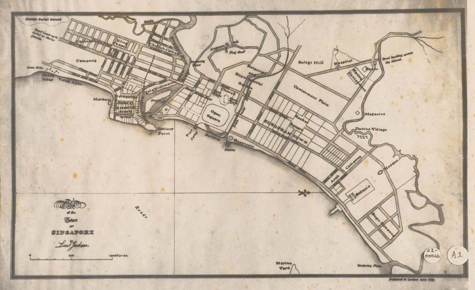
Singapore’s first documented map—also referred to as Raffles Town Plan—can be read as a blueprint for its development process ever since. The map does not depict territory as it was “discovered” by the British but already drafts an imaginary picture of Singapore. Its vision centres around the commercial district, which would shortly after be converted from marshlands into solid grounds, going down in history as the beginning of modern Singapore aka Raffles Place. The rest of the island is blank, its full contours missing entirely from the map. It becomes evident that the assigned rural areas of Singapore were in fact heavily populated, as demonstrated by the huge resettlement project that followed the colonial British era.
What I like to point out is that Singapore’s existence—at least in its modern formation—was always already a virtual existence. For Raffles, Singapore was worth conquering because of what it could become, not for what it is. Its central position between the South Chinese Sea and the Indian Ocean allowed the British to turn it into a prime trading spot in an area that at the time was largely dominated by the Dutch. The first reclamations was minor in comparison to the transformation that would follow, but it nonetheless marks a cornerstone of the integrated terraforming and nation-building project. This very first map acts both as a document of Raffles’ vision and an instruction for how to transform the grounds.
The projective mapping practice traces the establishment of Singapore like a red thread. While the Raffles Town Plan already points towards its operation as design tool, in 1958 the first Master Plan was released by the Singapore Improvement Trust (SIT)—a body implemented by the British government to tackle the informal housing situation deemed not adequate for the future of Singapore. Based on the expected population and desired economic growth, the Master Plan organises space, people and resources according to different zones and precincts.
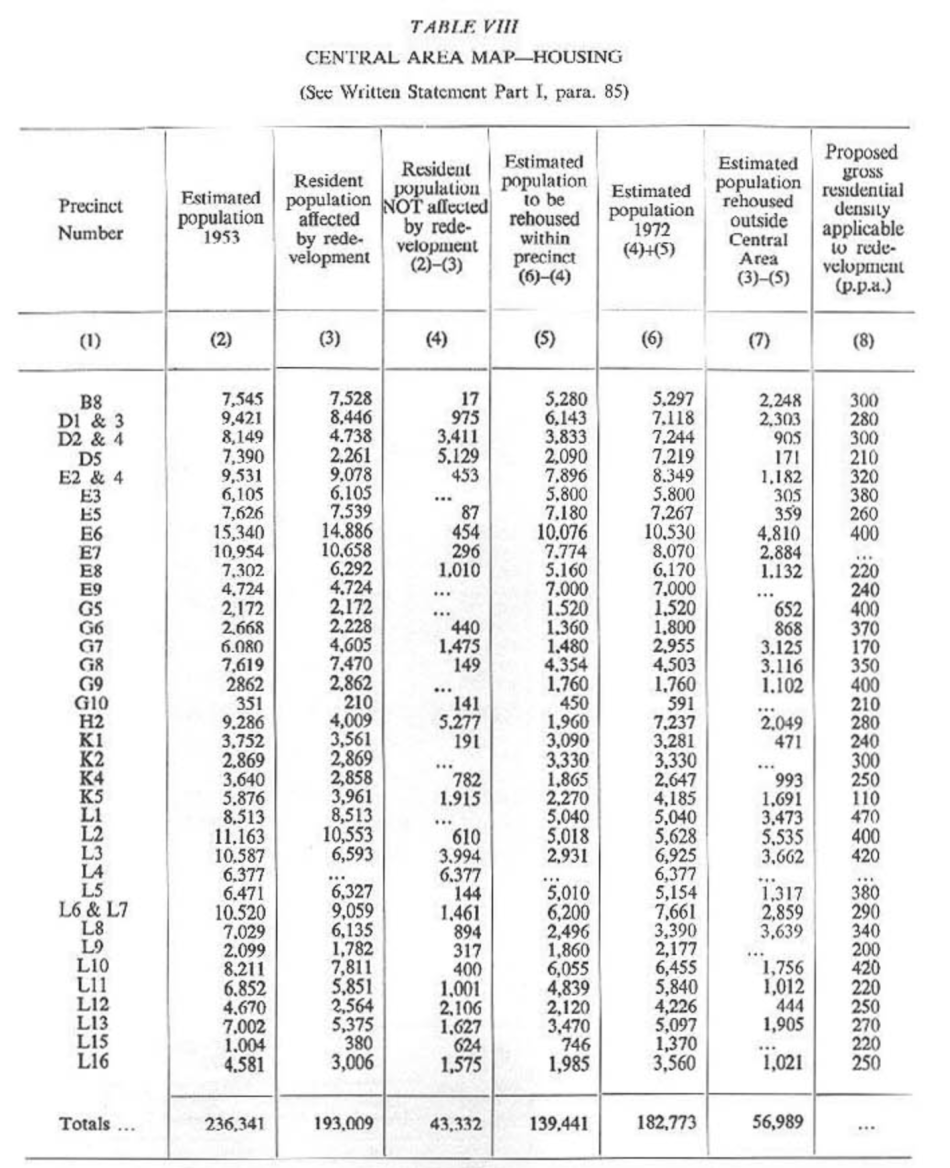
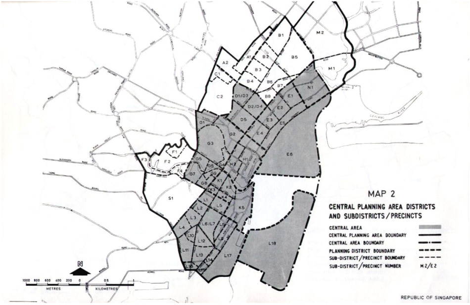
The replacement orders that were part of Singapore’s urbanisation process are not evident from the plan itself but contained in the appendix of the Written Statement to the Master Plan 1958. The “control of density” or in other sources referred to as "the clearing of the slums" went hand in hand with the establishment of the Central Business District. Paraphrased as “comprehensive redevelopment”, it required the rehousing of a quarter of the population from the Central and Urban Planning Areas to Urban and Rural Planning Areas. This was also the beginning of Singapore’s public housing programme, which continues until today, and allows eighty-five percent of the population to live in and own state-built housing. Promoted as a method of enabling each and every Singaporean to own their home, the origin of the programme lies in the rigid urban planning scheme which gave the government control over space and bodies in a "concerted and orderly manner".
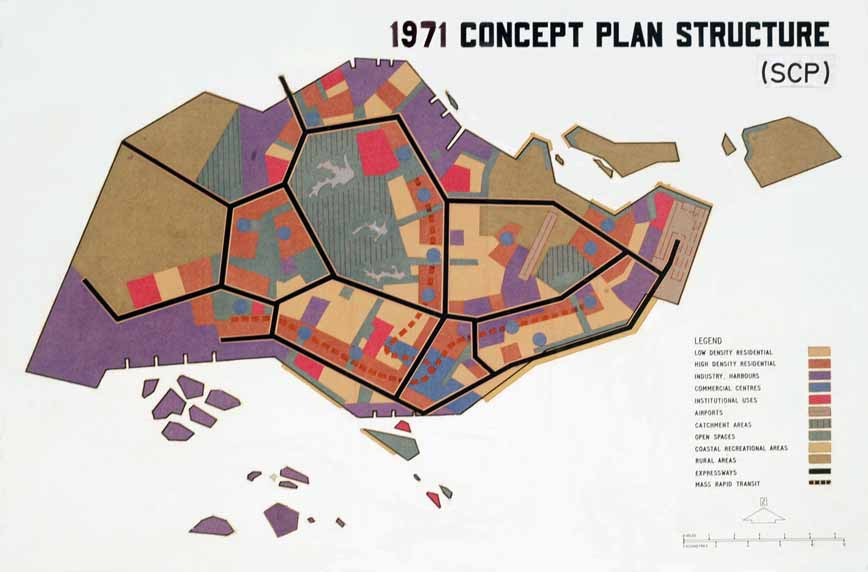
After the “basic infrastructural needs of a growing nation were fulfilled,” according to the official narrative, trading alone was not considered “capital-intensive” enough. It was through the invitation of a United Nations committee to help shape future directions that Singapore’s growth strategy was aligned with internationalisation and globalisation efforts in the global north. In order to achieve more strategic and long-term planning, in 1971 the UN committee introduced the Concept Plan. International investment, needed for the next stage of development, would only be executed if Singapore was considered reliable. Where the Master Plan was to focus on detailed zoning and implementation, the Concept Plan takes into consideration global developments, aligning Singapore’s spatial and economic growth strategy and thus its land use accordingly.
Both planning documents are renewed in accordance and at regular intervals, constantly reiterating both Singapore’s vision and its material reality. The speedy iteration of documents and the transformation of ground they project upon places Singapore in a continuum of change, where nothing seems to be stable or fixed—not even the ground. The sandcastle of Singapore starts to equal a fortress—while every square metre of newly reclaimed land geographically brings it closer to its neighbours Malaysia and Indonesia, the industrial and military belt designed via the land extension isolates it further, detaching Singapore from the region. Singapore’s addiction to sand never completely isolates it but instead creates a co-dependent relationship.
During more than half a century of dedicated urban planning efforts from 1958 onwards, Singapore’s development strategy has become more complex and detailed. The Concept Plan and Master Plan are further enhanced by the Land Use Plan by the Ministry of National Development, detailed development guide plans, and the Government Land Sales Programme. Seemingly effortlessly, the documents inscribe bodies and space with the vision of a global city. If one is to believe the promotional material, it is only through the redesign efforts that Singapore became “liveable". Yet, where does this liveability manifest? In the ever-projected version of Singapore, the ever-rebuilt version, or the gap between the two? The constant overwriting that takes place makes it difficult to comprehend Singapore. The city constantly seems to be ahead of itself.
In addition to the Master and Concept Plan, another document organises land yet to become: the Foreshores Act. Initially released in 1872 and amended several times, it ensures the right of the government to reclaim land for the purpose of commercial and industrial usage. More importantly, it expels any ownership over the seabed or maritime space that had previously been granted.
In its last amendment a no-compensation policy was introduced, cutting off any ties to the sea and coastal area inhabitants might have had. Alongside to the enactment of state power over land that does not exist, the dispossession of access to the sea can be understood as yet another attempt to detach the population from its past. Usually read as the tragic loss of identity for the community and a document to Singapore’s aggressive extension policy, it is also telling in what it does not address. While the act assesses claims over land to be reclaimed from the sea, how and where resources come from is not specified.
Since the 1980s sand is mostly sourced abroad, meaning that Singapore indirectly links its ownership claims to the extractive infrastructure upon which it capitalises. As global studies scholar Charmaine Chua states, Singapore not only presupposes “that the coastal sea itself acts somewhat as an aqua nullius, ‘empty’ space that has no history or value, except to be turned into the property of the state” but also that the reclamations are “coextensive with an active dispossession from elsewhere”. Once sand enters the national terrain of Singapore, it is considered to belong to Singapore. Through the dispossession and accumulation of sand “states are geophysically engineering the globe at a scale which shifts the very ground on which sovereignty is thinkable. The geophysical follows the geopolitical, rather than the other way around”.
Declaration regarding reclaimed lands (excerpt)
5.— (1) The President may, by proclamation published in the Gazette, declare any lands formed by the reclamation of any part ofthe foreshore of Singapore, or any areas of land reclaimed from the seato be State land, and thereupon that land shall immediately vest in theState freed and discharged from all public and private rights whichmay have existed or been claimed over the foreshore or the sea-bedbefore the same were so reclaimed. Except as provided, no action to be brought in respect of anydamage
6. Except as provided by this Act, no person shall be entitled toclaim, and no action or proceeding shall be brought, against the Government to recover any compensation in respect of any lands or ofany interest therein which have been injuriously affected by theexecution of the works.
No right to compensation
7.— (1) There shall, subject to subsection (2), be no right tocompensation in respect of any lands or of any interest thereinwhich may be injuriously affected whether on account of loss of seafrontage or for any other reason by the execution of the works.
Sand produces different meanings depending on where it settles. Land reclamation shows that it is not its origin that matters but its uptake. This assumes a stability which runs contra to sand’s physical behaviour. The grains of sand that demarcate Singapore’s coastline today will not be the same that demarcate it tomorrow. Winds and currents continuously erode and replenish beaches. Social concepts of ownership clash with matter’s "vibrancy". While sand is completely ignorant to how it is used, it still ceases to be mastered. Nevertheless, a lot of meaning is assigned to sand in its more or less stable configuration as land. This becomes especially interesting in the context of border conflicts arising from the results of dredging and reclamation works. In Indonesia alone twenty-five uninhabited islands are said to have disappeared because of extraction. These islands acted as flood protectors for bigger islands and their vanishing not only poses territorial conflicts but threatens the life of many Indonesians. Sand which might have belonged to one of these multiple islands is difficult to trace back once extracted, turning it into an ambiguous and malleable material ready to settle in Singaporean waters.
In its massive scale Singapore’s land reclamation forecloses what should be self-evident: sand and thus land is not stable. It is not only not stable when extracted and transformed, but its erosion defies control. Originating in a composite of rocks, shells, and plants, sand has the tendency to decompose, making efforts to stabilise it laborious. It is almost impossible to restrict sand from moving, from crossing and shifting borders. Reclaimed land must constantly be replenished to compensate for erosion. Because of its water-expansive qualities, reclaimed ground is less stable and prone to flooding. What seems like a formula for success quickly turns into a source of risk when sand supply becomes depleted.
Singapore’s growth strategy works as long as sand remains liquid, meaning allegedly cheap and abundant. Political ecologist Jason Moore describes the “cheapening of nature” as one of the pillars of capitalist accumulation. Alongside the cheapening of the work force, it is essential for continuous growth. The premise of exploitability is deeply ingrained in Singapore’s project rendering null all effort of sustainable development.
Both enclosed and foreclosed through the documents that accompany Singapore’s nation-building process, sand is simultaneously cheap, precious, and risky. To talk of the agency of sand and its potential to strike back might be an overdetermination, but it is important to acknowledge that the exploitative relationship does not come without its complexities. Not regulated because it is not considered precious enough, sand is so fundamental that it is easily overseen. As with most materials it is considered abundant until it is not. Once it is gone, once a riverbed or seafront erodes or floods, or one country’s sovereignty encroaches on another’s, sand is recognised as political. Despite efforts to control it, sand stays ambiguous, always in transition. It slips through the fingers just like Singapore slips away when attempting to grasp it.
-
Yew, Lee Kuan. From Third World to First: The Singapore Story - 1965-2000. Illustrated Edition. New York: Harper, 2000, 76↩
-
Chua, Charmaine. ‘“Sunny Island Set in the Sea”: Singapore’s Land Reclamation as Colonial Project’. In Digital Life in the Global City: Contesting Infrastructures, edited by Deborah Cowen, Alexis Mitchell, Emily Paradis, and Brett Story. Montréal: McGill-Queens University Press, 2020.↩
-
Huat, Chua Beng. ‘Singapore as Model: Planning Innovations, Knowledge Experts’. Worlding Cities: Asian Experiments and the Art of Being Global, 2011, 32.↩
-
Kung, Yihsiu Michelle. Built by Singapore: From Slums to a Sustainable Built Environment. First edition. Urban Systems Studies. Singapore: Centre for Liveable Cities, Singapore, 2015.↩
-
Urban Redevelopment Authority. ‘Draft Master Plan 2019 Special Edition. How Do You Want to Live, Work and Play in the Future?’ Skyline. Insights into Planning Spaces around Us, 2019, 5.↩
-
Jurong Town Corporation. ‘Who We Are | JTC’, 29 March 2022. https://www.jtc.gov.sg/about-jtc/who-we-are.↩
-
Urban Redevelopment Authority. ‘Draft Master Plan 2019 Special Edition. How Do You Want to Live, Work and Play in the Future?’ Skyline. Insights into Planning Spaces around Us, 2019.↩
-
Lamb, Vanessa, Melissa Marschke, and Jonathan Rigg. ‘Trading Sand, Undermining Lives: Omitted Livelihoods in the Global Trade in Sand’. Annals of the American Association of Geographers 109, no. 5 (3 September 2019): 1511–28; Powell, Miles Alexander. ‘Singapore’s Lost Coast: Land Reclamation, National Development and the Erasure of Human and Ecological Communities, 1822–Present’. Environment and History, 2019.↩
-
Chua, “Sunny Island Set in the Sea”, 8.↩
-
ibid. 6↩
-
Bennett, Jane. Vibrant Matter: A Political Ecology of Things. Durham: Duke University Press, 2010.↩
-
Milton, Chris. ‘The Sand Smugglers’. Foreign Policy (blog), 4 August 2010. https://foreignpolicy.com/2010/08/04/the-sand-smugglers/.↩
-
Welland, Michael. Sand: The Never-Ending Story. 1. Edition. University of California Press, 2009, 130.↩
-
Moore, Jason W. Capitalism in the Web of Life: Ecology and the Accumulation of Capital. New York: Verso, 2015, 16.↩
0 comments