Waiting, weighting
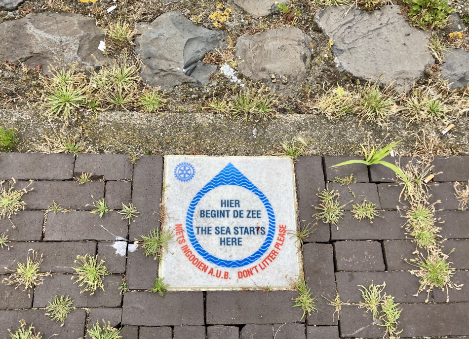
Hier Begint De Zee / The Sea Starts Here
Not quite adrift, we become oriented by the sea winds and waves while the captain of the Koningin Emma keeps the boat more or less steady outside the Zeesluis gates. On the top deck everything felt too hemmed in, all of us watching each other sideways, trying to figure out how to approach this waterscape engineering the dynamics between infrastructural circulation and pause, salt and freshwater, sea and canal, water and land. It is massive and claustrophobic simultaneously; the air presses; a bell sounds.
I arrive at this tidal lock from a different one, across the North Sea. Limehouse Lock is the interface between the tidal River Thames and a canal basin and former dock in East London. Unlike Zeesluis IJmuiden, which has recently been massively expanded to enable the largest ships to access the Port of Amsterdam, the lock at Limehouse was downsized in the late 1980s during the neoliberal redevelopment of the London Docklands.
The ships carrying coal, timber, and ice to be unloaded or transshipped in the basin via the canal network were replaced by boats like Willemijntje, the Dutch barge I live on, repurposed from their trade histories in the circulations of racial capitalism for the development of ‘regenerated’ sites of accumulation in waterside residential and recreational space. Willemijntje was built in a shipyard in Zeeland in 1903. A flat-bottomed boat designed to carry cargo around the shallow seas and inland waterways of the Netherlands, Willemijntje’s dimensions are shaped by these waterways: she is 19.9m long, 4.3m wide, with a maximum draught of 1.1m. The draught is the distance between the waterline and the bottom of the boat, and changes depending on the weight of the cargo. When my boatmate L brought Willemijntje through a tunnel on the London canals, she had to weigh the boat down with waterbags to get through.
Algal niches
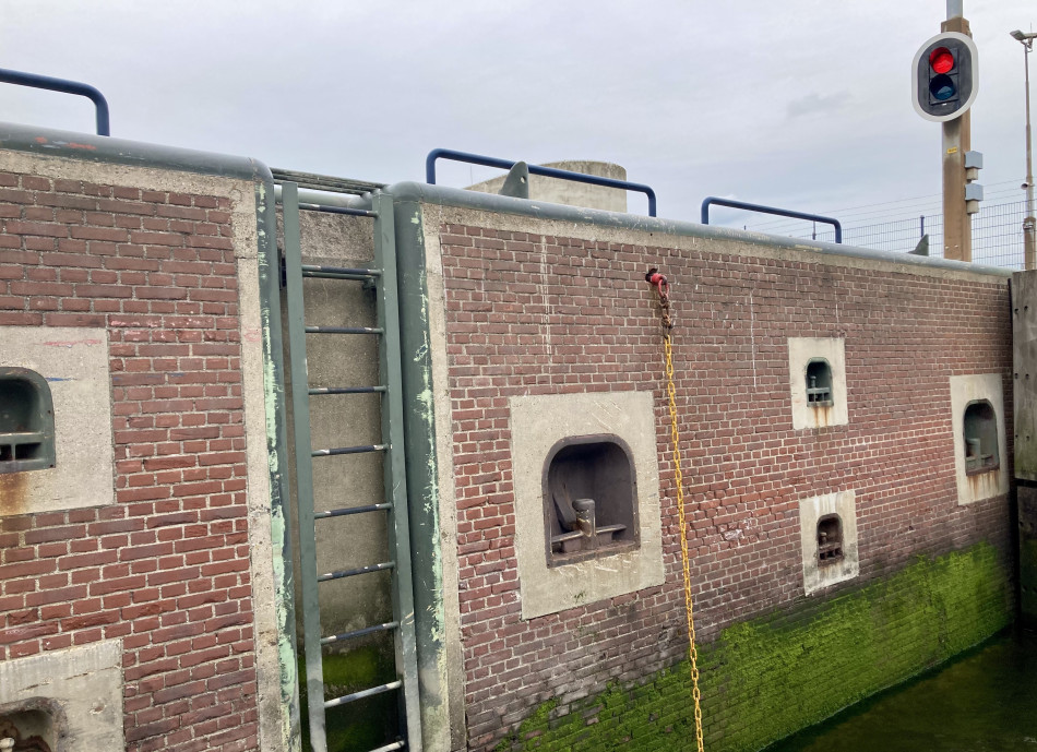
Slowly, the gates open, and the captain of the Koningin Emma steers us into the lock. The insides are red-brick at the top and algal green further down, and the walls are patterned with recesses housing mooring posts of multiple sizes and heights. Zeesluis IJmuiden is 500m long, 70m wide, and 18m deep, and allows passage for ships up to 399m long, 57m wide, with a draught of 13.75m in saltwater, 14.05m in freshwater (saltwater is denser than freshwater, pushing ships up higher in the water). Beside us is a Dutch barge, similar in size to Willemijntje, tiny against the lock’s dimensions. I've moved from standing on the top deck to sitting on the lower deck to be closer to the waterline, to be unable to see over the top of the lock, especially as the water level drops with the mechanism. The boat’s speaker system doesn’t reach here, so I can’t hear the captain’s commentary beyond a distanced burble of sound inside and upstairs. I am anxious about this, about missing information, about where the ‘field’ is on this boat. Legs curled awkwardly, I watch a cormorant slip below the metal of the water.
People have slowly settled into different spaces: M and I are asking the captain questions on and off; I and A are painting watercolours and making potions with L at one of the plastic-topped tables; L and C are on the other side of the front deck, suspending hydrophones into the water and listening through their headphones; F is cutting about between people and conversations. We wait for the water to drop from sea level to the level of the Noordzeekanaal. The canal is 15m below Normal Amsterdam Level (NAP), a measurement based on the average summer flood level in the seventeenth century in what was then the main shipping area in the IJ near Amsterdam. Much of the Netherlands is engineered from alluvial plains, a past waterscape of peat swamps, so water infrastructure and flood defences are crucial to the land’s continued existence.
Salinity gradients
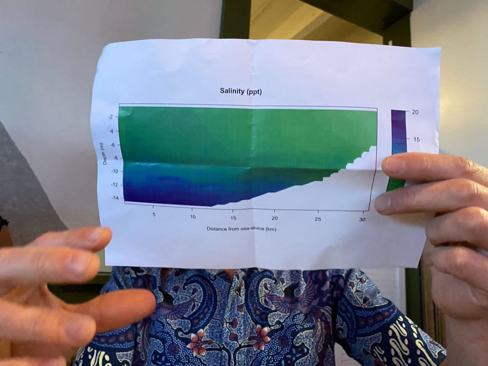
In the beachside bar (called Makai, meaning ‘towards the sea’ in Hawaiian but used more widely via the cultural appropriations and circulations of imperial capitalism), we meet Arie Vonk, a benthic ecologist from the University of Amsterdam. Arie shows us a graph of water salinity levels relative to depth and distance from the Zeesluis. On average, seawater is around 35ppt (parts per thousand, or grams per kilogram), and freshwater is 0.5ppt or less. On the graph the freshwater is green, the saltwater blue. On the left-hand side – representing the water close to the lock – the graph is green at the top, and shifting through a gradient to deepening blues at the bottom, the darkest blue indicating 20ppt in the water at the bottom of the channel. Arie notes that the graph would have looked almost reversed in the past.
At the time when NAP was first being measured out, Amsterdam’s waterfront – a brackish bay called the IJ – led out to the sea. Known as the Zuiderzee, this bay became increasingly less navigable by boats in the seventeenth century – the height of the Dutch East India Company (VOC)’s maritime imperial power – because of shoals and shallows. In The Black Shoals: Offshore Formations of Black and Native Studies (2019), Tiffany Lethabo King writes:
As a geological and oceanic formation, shoals force one to pause before proceeding. Prior to the 1860s, mariners and sailors lacked a scientific or systematic methodology for measuring depth to the ocean floor. Before the invention of bathymetry, the calculation of probability curves that estimated the latitude and longitude of shoals – rock formations, coral beds, and sandbars – were very difficult to map and, therefore, avoid.
Dutch barges were used to carry cargo transloaded from larger oceanic vessels that waited out in deeper waters. One of these places was the Rede von Texel, a roadstead or safe anchoring place used by Dutch East India Company and Dutch West India Company ships off Texel, an island of shifting sediments created by a flood and maintained by intense anthropogenic efforts (for more on the roadstead, see Miriam Matthiessen and Jacob Bolton’s field notes). In the wake of the durational and multi-scalar violences of colonialism, slavery, and racial capitalism maintained through the movements of ships, shoaling in King’s terms also becomes a methodology slowing down the terms reproduced by dominant analyses of Black and Indigenous life, attending to porous relations. When I walk around the port space at Oudeschild, Texel – a site of tourism and rusting ship chains and bilge pumps, but also key to Dutch voyages of empire and slavery – I don’t know what to do. I read articles online, I look into the water, I hear the free jazz collective Irreversible Entanglements’ track ‘The Port Remembers’ in my head. What would it mean for this port to remember the violences but also the lives and bodies and waters it is implicated in transforming, curtailing, enclosing? I wonder if I could not only take from but also put something (back) in this space, an imperfect ritual, a material rearrangement or proposition of (re)membering. I think of the low-lying coral islands in the Caribbean that Alexis Pauline Gumbs rhythms in her ancestral listening text Dub (2020):
you remember the depth and don’t ever forget the pulse and the float. you remember the breathing before the boat. you remember the hardening coral notes. you remember the reaching, the clawing, the hands. the need for sand. you remember the crawling, the suction, the sludge.
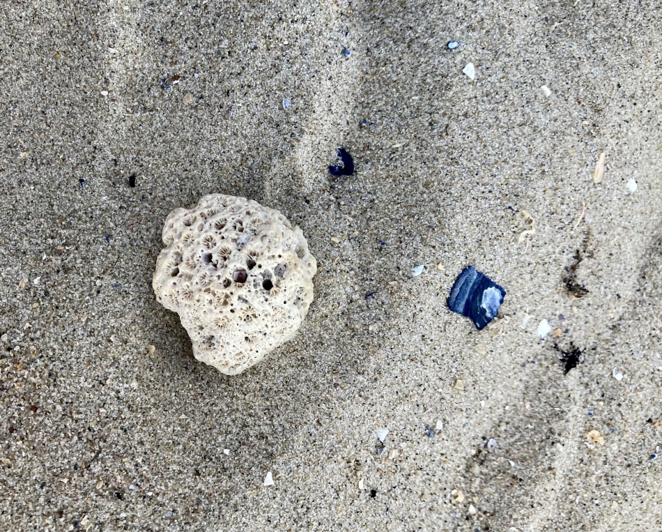
In this other, entangled, low-lying space, I decide to drop a small fragment of coral J gave me, which I have been carrying around in the pocket of my rucksack for months, into the sea. Slightly up the coast from the port, A and M and H and I put our bodies into the water; it is (perhaps too) warm and clear. When I can’t reach the sand with my feet anymore I let the coral drift from my palm. This gesture, this scale, feels deeply inadequate, yet I pause with it, tread water, try to hold for a moment the silted weights of this space.

Texel shallows
When new water infrastructures were designed and laboriously constructed to allow for routing around shoals, dynamics of waiting and weighting become re-traceable by salt. In the nineteenth century, two large canals – the Noordhollandsch Kanaal from Den Helder, and the Noordzeekanaal from IJmuiden – were dug out to lessen the need for the Rede von Texel, and to improve access to the Port of Amsterdam. With this change in access, in the twentieth century the formerly salty Zuiderzee was turned into a freshwater lake, the IJsselmeer, through an extensive combination of dikes, dams, drainage and land reclamation projects. This transformation happened within Willemijntje’s lifetime. I wonder if there are traces of salt in her from that time before.
With climate change and sea level rise, a ‘salt tongue’ presses deeper into the freshwater systems of the Netherlands. As Tracy Metz and Maartje van den Heuvel write, billions of litres of freshwater are pumped through polders and drainage ditches every day to try to push back denser saltwater from affecting agriculture, drinking water systems, and freshwater ecologies; meanwhile, droughts are also increasing. Zeesluis IJmuiden has a highly engineered system of ‘selectieve onttrekking’ (selective abstraction/extraction) that pumps saltwater from the locks back out into the sea. To enable this, the canal close to the lock had to be excavated and dredged 12m deeper, with huge sheet piles vibrated into the ground, and a 7m opening made at the bottom for the denser saltwater to flow through.
Zeesluis mechanisms
The day after we pass through on the Koningin Emma, I return to the Zeesluis. From the beachfront hotel at IJmuiden it takes an hour for me to walk with my luggage along the barren sides of roads where no one else is on foot. I'm used to walking long distances – it's something my body, for now, can do – but the space and scale are made for the movements of vehicles and ships, not legs. There are traffic lights everywhere, and I can’t work out which bridges I’m allowed to cross, which places are restricted to workers, which pathways might be broken up at any moment by the opening or closing of part of the lock system. I try to record the sound of one of the gates creaking open, but there is too much wind. I bump into M and J – who have cycled over – shouting questions to workers on a large oil tanker sailing under the flag of Panama waiting in the lock: Where are they coming from? How long have they been on the ship? The workers gather together to shout back, seemingly bored by the waiting that is built into port logistics, both infrastructural and economic mechanisms. M and J accidentally drop part of the microphone they’re using down to a lower level, a restricted area, and someone working on the locks retrieves it for them. We chat for a moment, all of us looking up the ship on the Marine Traffic app. We move off in different directions, rain gusting in from the sea. One of the refrains of the week – the field doesn’t want you here – rattles around my head. I thought repeating, returning, lingering, waiting differently, might open up other ways of understanding this space, a mode of infrastructural sensing that registers its own failures to mediate the multiple scales and queer temporalities of water and watery bodies oriented by infrastructural organisations and productions of space. Exhausted on the bus back to Amsterdam, I’m not sure.
There have been several complications and delays in the work to make the Zeesluis operational. Just weeks after we went through the lock on Koningin Emma, drought and lack of rain combined with the infrastructures of water management contributed to low water levels and high salt levels in the Noordzeekanaal. In drought conditions ships can carry less cargo, maximum draughts are smaller, the rhythms and patternings of boats in/along waterways have to shift. In response to the conditions, Rijkswaterstaat (the Dutch Directorate-General for Public Works and Water Management) changed the passage regime at the sea lock so that, rather than 24-hour access on demand, ships were made to pass through in blocks in order to limit the increased salinisation of the water.
Waiting happens in the frictions of infrastructures; waiting can also facilitate accumulation, a futures price, an additional port. What are the temporalities, durations, and delays of brackish infrastructures – how do they disrupt capital flows and/or enable continued accruals of value? What orientations and forms of attention could sense the materialities of infrastructural transformation and colonial bearings in brackish waters? How could we wait/weight differently, and who with?
Coral pause
with distributions of waiting, the port
blobs, salt-tonguing half-filled bulk
accrues between swirls across gaps
can be heaped recrustic, irreversible—
-
Port of Amsterdam, ‘Sea Lock: Built for the Future’, https://www.portofamsterdam.com/en/zeesluis-ijmuiden.↩
-
Tiffany Lethabo King, The Black Shoals: Offshore Formations of Black and Native Studies (Durham: Duke University Press, 2019), p. 2.↩
-
Daniel Boffey, ‘Ship drawing sheds new light on Amsterdam’s role in slave trade’, The Guardian, 30 June 2020, https://www.theguardian.com/world/2020/jun/30/ship-drawing-sheds-new-light-on-amsterdams-role-in-slave-trade.↩
-
Irreversible Entanglements, ‘The Port Remembers’, Open the Gates (International Anthem, 2021).↩
-
Alexis Pauline Gumbs, Dub: Finding Ceremony (Duke University Press, 2020), p. 32.↩
-
Tracy Metz and Maartje van den Heuvel, Sweet and Salt: Water and the Dutch (Rotterdam: NAi Publishers, 2012), p. 25.↩
-
Rijkswaterstaat, ‘Selectieve Onttrekking: bouw van de zoutdam bij Zeesluis IJmuiden | Animatie’, online video recording, YouTube, 11 January 2023, https://www.youtube.com/watch?v=x9SUV3KQCbE.↩
-
Liquid Time, ‘Shipping Doesn’t Do What Everyone Says it Does’, Weird Economies, 17 April 2023, https://weirdeconomies.com/contributions/producing-circulation.↩
-
Marine Insight News Network, ‘The North Sea Canal Recorded High Salt Levels Due to Lack of Rain in the Netherlands’, Marine Insight, 22 July 2022, https://www.marineinsight.com/shipping-news/the-north-sea-canal-recorded-high-salt-levels-due-to-lack-of-rain-in-the-netherlands/.↩
-
Laleh Khalili, Sinews of War and Trade: Shipping and Capitalism in the Arabian Peninsula (London: Verso, 2020).↩
0 comments