Sensing Scale at Hwlhits’um/ Brunswick Point
Notes from for the field w/ the Staľəw/Fraser River Studies Class
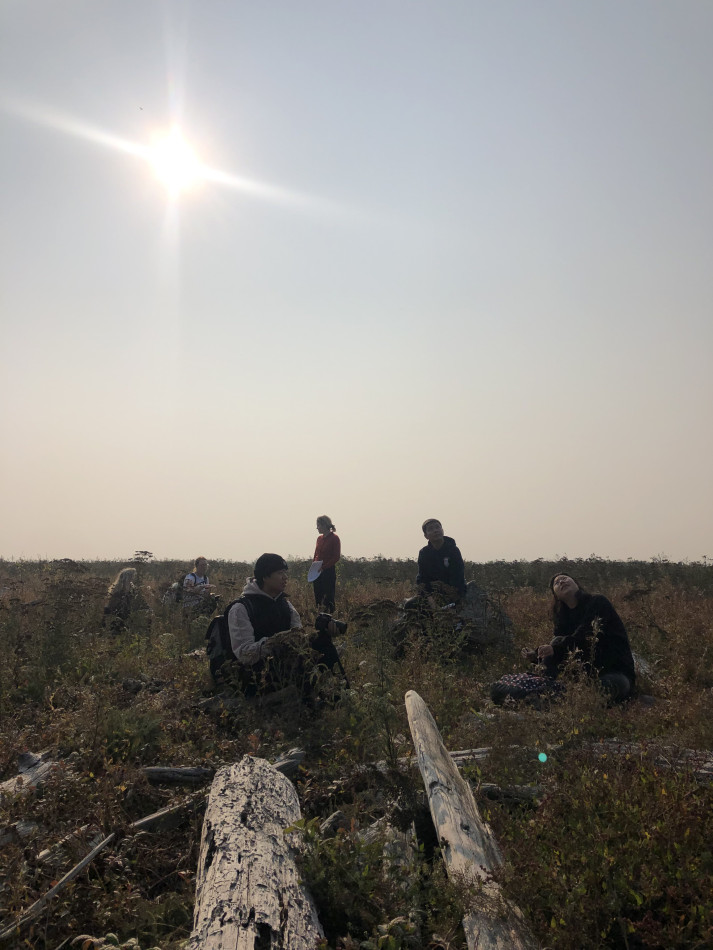
On a smoky morning in October 2022, I met with the Staľəw/Fraser River Studies class–a 4th-year studio art class and their prof Liz Toohey-Weise–at Hwlhits’um/Brunswick Point. This place is the shared and asserted territory of numerous Coast Salish Nations including the the Hul’qumi’num Mustimuhw (Hul’qumi’num Treaty Group of Seven Coast Salish Nations), sc̓əwaθən məsteyəxʷ (Tsawwassen First Nation), and xʷməθkʷəy̓əm (Musqueam). It is south of what is now known as Vancouver, Canada, in the suburb of Delta. From here, we’ll walk a trail along the dykes of the River following the sandy intertidal Roberts Bank, getting as close as possible to what's known as the Port of Vancouver’s‘outer harbour, or Deltaport. Built at the mouth of the Staľəw/Fraser Estuary, where its sediment-rich waters merge and mix with the Salish Sea, large coal and container terminals sit atop an artificial island, built at the end of a 5km jetty extending past the shallow mudflats into the sea. The port is a significant presence in this estuarine landscape even though it is many kilometers away out at sea, its presence is felt not primarily through sight but from the deep rumbling sounds that extend across the space.
Meeting at the mouth of the delta, we’re going to make collective sense of the meeting of this socio-ecology–a Coast Salish Space, a settler colonial port, an industrial space, a stop of the Pacific Flyway and bird refuge, an ecotone. This is a unique class for the studio art students, who have been asked to “engage with various forms of knowledge, such as ecology, history, and Indigenous ways of knowing to deepen their own relationship with this watershed” (LTW). Going into the field is critical to this. After spending time on the river and its tributaries with stream-keepers, ecologists, and artists, the students are tasked with creating a series of singular and collective projects that will “reflect on the past, present, and future of this important river.”
Liz and I have been in conversation about this place and its politics, and how to think, represent, and make sense of them for over a decade. For her, this has taken shape through artistic practice, primarily painting but also textiles. For me, it's taken the form of academic research and writing–structured, these days, by a PhD dissertation about the logistical infrastructures and relationships that shape this watershed. Liz asked me to join her class to walk and talk with them about the ongoing history of logistical and extractive infrastructures at the mouth of the estuary.
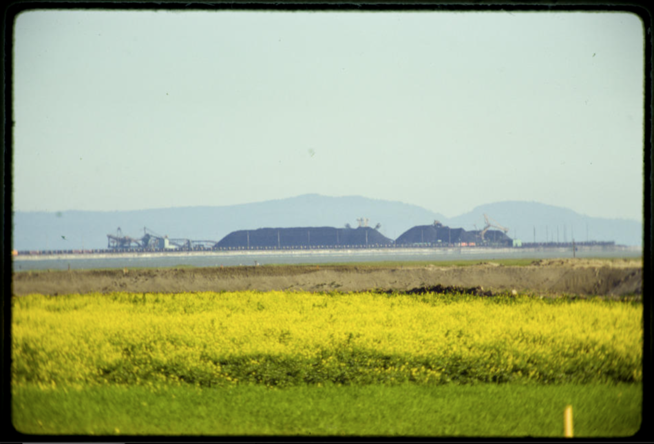
Image of Roberts Bank Coal Port, 1975, British Columbia Archives: Item I-11197, Beautiful British Columbia Magazine Slide Album.
On one side of the dyke are farm fields of potato and rye as fallow ground cover. On the other are marshy shorelines, leading out onto Roberts Bank, an 800-hectare sandy intertidal mudflat. This is the
Deltaport was built in the late 1960s as an export terminal where the coal from western Canada and the US would be shipped as feedstock for a growing Japanese automotive industry. In recent decades, pressure from environmental groups has led many US states and cities in the Pacific Northwest to ban coal exports. Finding ways to circumvent these bottlenecks, trains full of American coal have since been rerouted northward to the Port of Vancouver. Today Westshore coal terminals boast being the ‘busiest coal port’ in North America.
Many of the world’s largest cities and ports have been built at the mouth of estuaries. These brackish ecotones increasing feeling the pressures of logistical urbanism. Through the dual practices of dredging and land reclamation, massive amounts of sand, silt, and clay are leveraged to build the grounds and deepen the waters of growing just-in-time circulatory infrastructures to support a global economy increasingly reliant on maritime shipping. The Staľəw estuary is a hub of industrial activity, lined with marine bulk and container terimials, warehouses, fulfillment centres, log booms, cement factories, the BC Ferries Tsawwassen Terminal, among other infrastructures. There are numerous proposed development projects along the lower river: a jet fuel storage facility, liquid natural gas (LNG) and coal terrminals, the highly contested Transmountain pipeline expansion and an expansion to the existing container terminal at Deltaport, Roberts Bank Terminal 2.

Listening exercise.
Part 1: [spatial] Sit down on some logs next in the mudflats. Listen for 1 minute. You can close your eyes if you want. Take note of four sounds you hear most prominently. What is the furthest sound? What is the closest sound you can hear?
Part 2: [temporal] Still sitting. Tune in again. Choose a sound. What happened to bring this sound into being here and now? Sound is often experienced as fleeting, but its composed historically through a series of relationships.
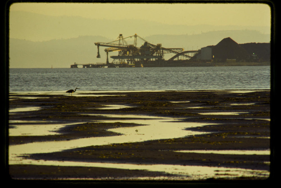
Mudflats and crane in front of Roberts Bank Coal Port, 1975, British Columbia Archives: Item I-11198, Beautiful British Columbia Magazine Slide Album.
Block error: "Undefined array key 1" in block type: "text"
Technologies of scaling are central to the work of globalized logistics, most famously the container and the computer. Connecting the world around this capitalist cartography has brought numerous political, economic, environmental, and sociocultural consequences. The scaling of these systems relies on quantitative practices that bring qualitative shits, that call on interpretive methods. The problem of apprehending the scale of global capitalism and its sinews of circulation, and logistics, is one that has occupied social theory.
The problem of scale is similarly central to ecological thinking, most tangibly through the problem of climate as a scalar concept that exceeds human perception. Yet our experiences of this drought, haze, and the anxious feeling that hangs in the air with them as we walk the dyke are suggestive of something that seems undeniably climactic. Changes of a scale that both exceed and register in bodies, environments and the relations between them.

Deltaport terminal. May 2023. Image by author.
In western thought and literature the sea has long presented a perhaps at this point cliched limit case of human mastery. The river similarly defies the permanence of fixed human structures and intentions, washing away, pushing sand banks, moving sediment. The way it frustrates engineering efforts differs from the sea. The river ecology is just as much a part of this logistical environment but it exits at a different scale than the ocean, and so do its infrastructures. To be out at sea often implies a distance from land. The river is flanked by muddy banks, marshes, sloughs, streams. The river is never so far from the shore. Ecologically and logistically, the scale of the river differs from that of the sea. Along the shorelines of the river are smaller operations. Log booms. Tug boats pull barrges of wood chips. Old canneries. Cement factories. Regional and bygone economies. A dog park, a parking lot. Larger scale terminals, host to ocean going international vessels brings tighter security. Fenced terminals require a port pass for entry. These are intended to restrict both movemments in and out. To prevent seafarers from “jumping”--a reference to ‘jumping ship’--an ITF representative tells me. A concern of shipping comapnies these days that is further restricting the movement and shore-leave offered to those who work aboard ships.

Log boom on the south arm of the river. July 2023. Image by author.
[Scale exercise]: As artists, writers, or those seeking to expresss or represent these multiscalar relations, we make judgements. Select the frame. Draw the box. Make the cut. Take 15 minutes to walk alone or in smaller groups, along the dyke or into the mudflats. Option 1. Take a photo with your phone. Option 2. Choose an object that you can hold. Return back to the group. Show us your image. Tell us about the frame. What relations are shown inside of it? What connections is it suggestive of? What does it leave out? Those that chose an object: describe what drew them to it. What timescales intersect in bringing this object to be and to this place?
-
Chua, Charmaine. “Circulation Revisited: A Forum on the Topicality of the Concept.” German Journal for Media Studies 23, no. 2. https://zfmedienwissenschaft.de/online/circulation-revisited-charmaine.Bulowski, Natasha. “Unions and Environmentalists Team up in Bid to Sink B.C. Port Expansion Project.” Canada’s National Observer, June 14, 2023, sec. News. https://www.nationalobserver.com/2023/06/14/news/unions-and-environmentalists-team-sink-bc-port-expansion-project.↩
-
Kinkle, Jeff, and Alberto Toscano. Cartographies of the Absolute. Zero Books, 2015.↩
0 comments